Mastering Underwater Mapping Techniques in Archaeology
Underwater mapping techniques play a crucial role in archaeology, providing invaluable insights into our submerged cultural heritage. These techniques have revolutionized the field by allowing archaeologists to explore and document underwater archaeological sites with unprecedented accuracy and detail. Through the use of advanced technologies such as sonar, photogrammetry, and remote sensing, researchers are able to uncover hidden treasures and unravel the mysteries of our underwater past.
The importance of underwater mapping techniques in archaeology cannot be overstated. It is through these techniques that we are able to preserve and protect our submerged cultural heritage, ensuring that it is not lost to the depths of time. By accurately mapping underwater sites, archaeologists are able to document and record the locations of important artifacts and structures, allowing for their preservation and further study.
These techniques have revolutionized the field of archaeology in numerous ways. Prior to the development of underwater mapping techniques, accessing and studying submerged archaeological sites was challenging and often limited to divers physically exploring the site. However, with the advancements in technology, researchers are now able to conduct non-invasive surveys and capture high-resolution imagery of underwater sites. This has led to a wealth of new discoveries and a deeper understanding of our past.
By utilizing sonar and bathymetry, archaeologists are able to create detailed maps of underwater landscapes, including the shape and depth of the terrain. This enables researchers to identify potential archaeological sites and plan targeted excavation projects. Photogrammetry is another crucial technique that allows for the creation of 3D models of underwater structures, providing a more immersive and detailed view of the site. Additionally, remote sensing techniques such as satellite imagery and aerial surveys help archaeologists identify submerged features that may not be visible to the naked eye.
The ability to accurately map and document underwater archaeological sites has been a game-changer in the field. These techniques have not only contributed to our understanding of history and cultural heritage but have also raised awareness about the need for conservation and protection of these underwater treasures. By mastering underwater mapping techniques in archaeology, we are able to unlock the secrets of the past and ensure that future generations can continue to explore and learn from our submerged cultural heritage.
Table of Contents
The Basics of Underwater Mapping
Underwater mapping plays a crucial role in archaeology, allowing us to explore and document submerged cultural heritage. This field has experienced a revolution in recent years, thanks to the development of advanced mapping techniques. These techniques have provided us with valuable insights into our submerged past, shedding light on ancient civilizations and preserving their artifacts for future generations.
One of the main technologies used in underwater mapping is sonar and bathymetry. Sonar systems emit sound waves that bounce off underwater features and return to the receiver, creating a detailed map of the seafloor and its topography. Bathymetry, on the other hand, focuses on measuring the depth and contours of underwater surfaces, contributing to accurate mapping.
Another important technology employed in underwater mapping is photogrammetry. This technique involves capturing multiple high-resolution images of an area from different angles. These images are then processed to create a precise three-dimensional model of the underwater site. Photogrammetry allows archaeologists to explore submerged structures in great detail and make accurate measurements.
In addition to sonar and photogrammetry, remote sensing plays a crucial role in underwater mapping. Remote sensing uses sensors and instruments to collect data from a distance, providing valuable information about underwater features and their surroundings. This technique is particularly effective in detecting submerged cultural heritage sites and assessing their conditions without the need for direct contact.
Accurate data collection is essential for successful underwater mapping. It enables archaeologists to create detailed maps that accurately represent the underwater features and their spatial relationships. By ensuring accuracy in data collection, archaeologists can analyze the data more effectively and make informed interpretations about the submerged cultural heritage. Thus, mastering underwater mapping techniques is crucial for preserving history and understanding our past.
Challenges in Underwater Mapping
Mapping underwater sites presents unique challenges for archaeologists, who must navigate through a variety of obstacles to obtain accurate data. One of the main challenges is poor visibility and murkiness, caused by sediment and algae suspended in the water. This limited visibility makes it difficult for archaeologists to accurately document and record submerged cultural heritage.
Another challenge is the presence of currents and tides, which can create strong water movement that affects underwater mapping. These dynamic forces can make it challenging to maintain stability and control while collecting data, leading to potential inaccuracies in the final mapping results.
Furthermore, underwater sites often feature complex morphological features such as rocks, vegetation, and underwater structures. These elements can obstruct the mapping process, hindering the collection of precise data. Archaeologists must navigate around these obstacles to ensure comprehensive coverage and accurate documentation of underwater archaeological sites.
These challenges significantly impact data acquisition and accuracy in underwater mapping. Poor visibility limits the ability to capture detailed imagery and inhibits the identification of submerged cultural artifacts. The presence of strong currents and tides can cause disturbances, affecting the quality of data collected. Additionally, complex morphological features can introduce errors in mapping, making it crucial for archaeologists to carefully navigate and collect data to ensure accuracy. Overcoming these challenges requires specialized equipment, expertise, and careful planning to effectively master underwater mapping techniques in archaeology.
Advanced Techniques for Underwater Mapping
When it comes to underwater mapping in archaeology, advanced techniques play a crucial role in achieving precise and accurate results. By delving into these techniques, archaeologists can uncover hidden secrets of our submerged past. Let’s explore some of these advanced techniques used by experts in the field.
Side-scan sonar for high-resolution imagery
One of the most widely used techniques in underwater mapping is side-scan sonar. This technology allows archaeologists to capture high-resolution imagery of the seafloor by emitting sound waves and measuring their reflections. The sonar system creates detailed images that reveal submerged structures and artifacts, providing valuable insights into underwater cultural heritage.
However, it’s important to note that side-scan sonar does have its limitations. It requires specialized equipment and trained operators to ensure accurate data collection. Additionally, the cost involved in using this technique can be significant. Despite these limitations, side-scan sonar remains an essential tool for underwater mapping due to its ability to capture detailed and informative imagery.
Multibeam sonar for detailed bathymetric mapping
Another advanced technique that has revolutionized underwater mapping is multibeam sonar. This technology allows archaeologists to create detailed bathymetric maps of the seafloor by measuring the depth of the water using multiple beams. By collecting a large number of depth measurements, experts can generate three-dimensional representations of underwater landscapes.
Multibeam sonar offers numerous benefits for underwater mapping, including its ability to provide highly accurate and detailed bathymetric data. This information is crucial for understanding the topography of submerged sites and identifying potential areas of interest for further exploration. However, like side-scan sonar, multibeam sonar requires specialized equipment and expertise, making it a resource-intensive technique.
Underwater photogrammetry for creating 3D models
In recent years, underwater photogrammetry has gained popularity as an advanced technique for underwater mapping. This method involves capturing a series of high-resolution photographs of underwater sites and using software to stitch them together into detailed 3D models. Using these models, archaeologists can analyze and measure underwater structures and artifacts with great precision.
One of the significant advantages of underwater photogrammetry is its relatively affordable and accessible nature compared to other advanced techniques. It does not require specialized equipment like sonar systems and can be conducted using standard cameras. However, challenges may arise due to limited visibility and the need to account for water distortion in the photographs.
In conclusion, mastering underwater mapping techniques in archaeology requires the understanding and utilization of advanced techniques. The use of side-scan sonar, multibeam sonar, and underwater photogrammetry provide archaeologists with the ability to capture high-resolution imagery, create detailed bathymetric maps, and generate 3D models of underwater sites. While each technique has its benefits and limitations, they all contribute to the advancement of our knowledge about the submerged cultural heritage. As technology continues to evolve, it is essential to explore new possibilities and embrace emerging techniques to further enhance our understanding of our submerged past.
Case Studies of Successful Underwater Mapping
Underwater mapping techniques in archaeology have proven to be invaluable in uncovering significant archaeological discoveries. Let’s explore some notable case studies where these techniques have yielded remarkable results, shedding light on our history and cultural heritage.
The mapping of a shipwreck site resulting in the preservation of artifacts.
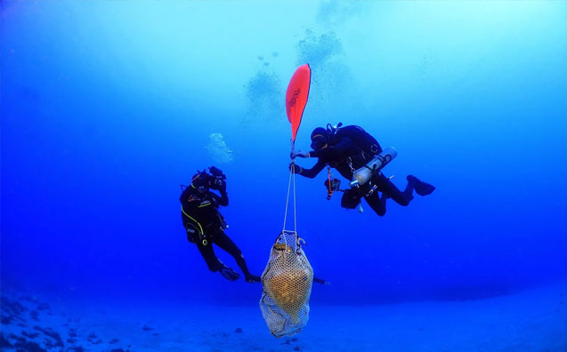
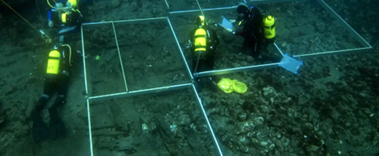
One remarkable success story is the mapping of a shipwreck site that led to the preservation of numerous artifacts. Through the use of sonar and bathymetry technologies, archaeologists were able to accurately map the wreck and its surrounding area. This meticulous mapping allowed for delicate excavation work, ensuring the preservation of fragile objects while providing valuable insights into the ship’s construction and cargo. This discovery helped deepen our understanding of ancient maritime trade routes and navigational practices during that era.
The discovery of submerged ancient cities through detailed bathymetry.
Another fascinating outcome of underwater mapping techniques is the discovery of submerged ancient cities. By employing detailed bathymetry, archaeologists have been able to create precise maps of underwater landscapes, revealing the remains of long-lost civilizations. These submerged cities offer a glimpse into the lives and cultures of our ancestors, contributing to our understanding of the development and decline of ancient societies. They provide valuable evidence of human settlement patterns, architecture, and even urban planning.
Mapping submerged caves uncovering prehistoric remains.
Underwater mapping has also played a pivotal role in uncovering prehistoric remains in submerged caves. By utilizing advanced technologies such as side-scan sonar and underwater photogrammetry, archaeologists have been able to create detailed maps of these underwater caves, revealing hidden treasures from the past. These discoveries not only provide insights into the lifestyles and behaviors of prehistoric communities but also allow us to reconstruct ancient environments and explore the connection between humans and their natural surroundings.
Discuss the impact of these findings on our understanding of history and cultural heritage.
The findings from these underwater mapping case studies have had a profound impact on our understanding of history and cultural heritage. They have challenged existing narratives and provided new perspectives on ancient civilizations. By uncovering shipwrecks, ancient cities, and submerged caves, these discoveries have allowed historians and archaeologists to reconstruct lost worlds and piece together the puzzle of our past. They also emphasize the importance of preserving underwater archaeological sites and implementing effective mapping techniques to ensure accurate data collection and preservation of cultural heritage.
These case studies demonstrate the power of mastering underwater mapping techniques in archaeology. They highlight the importance of accurate data collection, advanced mapping technologies, and the need for continuous exploration and development in this field. By embracing these techniques and pushing the boundaries of technology, we can continue to unlock the secrets of our submerged past, enriching our understanding of history and cultural heritage for generations to come.
Future Directions and Potential
The future of underwater mapping in archaeology looks promising, with emerging technologies and techniques that have the potential to revolutionize the field. High-resolution laser scanning is one such technology that holds immense possibilities. This technique involves using lasers to capture precise measurements of underwater features, allowing for highly detailed mapping of submerged sites. By providing accurate and intricate data, high-resolution laser scanning can contribute to a more thorough understanding of underwater cultural heritage.
Another promising advancement is the use of underwater drones for data collection. These unmanned vehicles can navigate underwater environments, collecting data and imagery that can be used for mapping purposes. Underwater drones equipped with sonar or photogrammetry technology can provide valuable insights into submerged sites in a more efficient and cost-effective manner. However, the use of drones in underwater mapping also presents challenges, including navigation in challenging environments and the need for skilled operators.
Artificial intelligence (AI)-assisted data analysis is another area with great potential for the future of underwater mapping in archaeology. By using algorithms and machine learning, AI can assist in the interpretation and analysis of vast amounts of data collected during underwater mapping expeditions. This can help archaeologists identify patterns, uncover hidden features, and make connections that may have otherwise gone unnoticed. However, the implementation of AI in underwater mapping requires careful consideration of ethical and privacy concerns, as well as the need for skilled personnel to operate and interpret the AI systems.
These advancements in technology and techniques present a multitude of potential benefits for underwater mapping in archaeology. By employing high-resolution laser scanning, underwater drones, and AI-assisted data analysis, researchers can enhance their ability to uncover and preserve submerged cultural heritage. These technologies can provide more detailed and accurate mapping data, potentially leading to the discovery of new sites and a deeper understanding of our past.
However, despite their potential, these advancements also come with challenges. The high cost and technical requirements of implementing high-resolution laser scanning and underwater drones may limit their widespread use. There is also a need to ensure the development of standardized protocols and guidelines for AI-assisted data analysis to ensure consistency and reliability in the interpretation of results. Additionally, the ever-changing nature of underwater environments poses ongoing challenges for these technologies, requiring continuous innovation and adaptation.
In conclusion, the future of underwater mapping in archaeology holds exciting possibilities. High-resolution laser scanning, underwater drones, and AI-assisted data analysis have the potential to transform how we explore and understand submerged cultural heritage. However, careful consideration of challenges and ethical implications is necessary to ensure the responsible and effective use of these advancements. By embracing new technologies and techniques, we can continue to unlock the secrets of our submerged past and preserve our cultural heritage for future generations.
Conclusion
Underwater mapping techniques play a crucial role in the field of archaeology, providing researchers with valuable insights into our submerged past. Mastering these techniques is essential for accurately mapping underwater sites and preserving our cultural heritage.
Throughout this blog post, we have explored the importance of underwater mapping techniques and how they have revolutionized the field of archaeology. By utilizing technologies such as sonar, bathymetry, photogrammetry, and remote sensing, researchers are able to collect accurate data that allows them to create detailed maps of underwater sites. Accurate data collection is crucial for successful underwater mapping.
However, underwater mapping comes with its own set of challenges. Poor visibility, currents, tides, and complex morphological features pose obstacles for archaeologists, impacting data acquisition and accuracy. Despite these challenges, advancements in technology have allowed researchers to overcome these obstacles and continue to make significant discoveries.
Advanced techniques, such as side-scan sonar, multibeam sonar, and underwater photogrammetry, have been instrumental in precise underwater mapping. These techniques provide high-resolution imagery, detailed bathymetric mapping, and the ability to create 3D models, respectively. Each technique has its own benefits and limitations, including cost and technical requirements.
This blog post has also showcased notable case studies where underwater mapping techniques have yielded significant archaeological discoveries. Shipwreck sites, ancient cities, and submerged caves have all been mapped, resulting in the preservation of artifacts and the uncovering of prehistoric remains. These findings have had a substantial impact on our understanding of history and cultural heritage.
Looking towards the future, there are emerging technologies and techniques that have the potential to further revolutionize underwater mapping in archaeology. High-resolution laser scanning, underwater drones for data collection, and AI-assisted data analysis offer exciting opportunities for researchers. However, with these advancements come new challenges and considerations.
In conclusion, mastering underwater mapping techniques in archaeology is crucial for unlocking the secrets of our submerged past. These techniques provide valuable insights into our history and cultural heritage, preserving artifacts and uncovering ancient cities. It is important to continue exploring and developing the field of underwater mapping, as it holds immense potential for further discoveries and advancements in the future.

